An introduction to my research activities

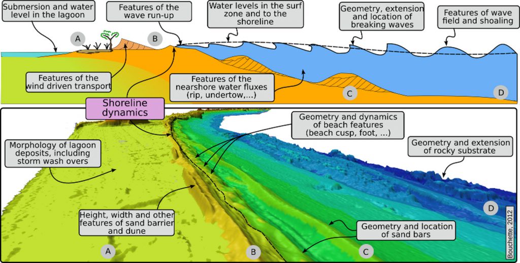
My scientific activity concerns the development of concepts and methods in relation with the dynamics of shallow water environments. I study the domain that extends from a few tens of meters of water depth at sea to the coastal watershed onshore, with a particular emphasis on the littoral area and the shoreline itself. In the littoral system, I focuss on the understanding of hydro-morphodynamic processes at different time and space scales. Sometimes, I use these concepts to improve our knowledge of the dynamics of ancient geological systems. I also make a significant effort to transfer this knowledge to engineering. But my preferred activity is to move borders in between geosciences, physics and applied mathematics.

In the sections below, I tentatively provide brief descriptions of some of my works, combining results from existing papers and on-going works. Well, this is a theoretical will.
Quantitative littoral geomorphology

Theoretical concepts and applications.

Article
Control of wave and beach features on the dynamics of wash-over fans

From LIDAR data, wave time series and a set of aerial photos of the Gulf of Lions since the 40', we determined fundamental relationships between wave forcings, beach features and wash-over dynamics.

Article
The dynamics of cuspate spits

Cuspate spits are typical geomorphic features (see the picture above) that develop along a shoreline affected by shallow water waves. Together with my friend Miguel Manna, we developed a full theory to understand their nucleation and their growth through time. This works combine intimately quantitative geomorphology and physics.

Article
Derivation of a non-linear Pelnard-Considère equation

The Pelnard-Considère equation is a diffusion equation extensively used for the modelling of shoreline dynamics. However, it is a linear equation that cannot manage the growth of shoreline instabilities such as sand spits, cuspates,... We derive a new formalism from scratch, which introduces some kind of non-linearity and offer new striking opportunities to model shoreline features.

Coastal & beach engineering

Article
Wave forecasting by fuzzy logic inference systems

Fuzzy logic inference systems (FIS) allows to determine reccurent matching patterns in trends of data. Georgios Sylaïos (a friend at University of Xanthi) developed a methodology to predict wave features with FIS. It is applied to the forecasting of coastal wave regimes.

Article
Optimization of the positioning of geotubes to fight against beach erosion

The theory of the optimization provides a fascinating point of view to enhance the design and the positioning of coastal defence structures in the nearshore. We present here how we used optimization to find the best place for geotubes to fight against the erosive impact of storm waves on the Lido de Sète (Gulf of Lions).

Article
Growth velocity of tombolos

From my work with Miguel Manna on cuspate spits, I derived an exact formulation for the growth of a tombolo, in the lee side of an artificial breakwater (picture above). This formulation relates the age of the tombolo to its size, and to parameters such as longshore diffusivity \(G0\) and wave features such as \(Hs\) or \(T01\).

Geophysics and littoral dynamics

How to use seismology, InSAR imagery and other similar geophysical stuff to tackle questions in relation with coastal dynamics.

Article
Decennal subsidence of beach piers and jetties by InSAR

InSAR allows to quantify very accurately the vertical/horizontal displacements through time of local points onto the earth surface. We use InSAR to quantify the subtile subsidence of jetties in coastal areas.

Article
Determination of the littoral longshore transport by the analysis of seismological data

Shocks between grains during coastal transport and water mass compression drive a seismic noise which is recorded by the devices traditionnally dedicated to the survey of earthquake activity. We explore this signature to quantify some relevant coastal informations on sediment transport and wave features to the shoreline.

Article
Using ambiant seismic noise to characterize storm tracks

The analysis of the time-spatial distribution of peculiar patterns within the ambiant noise recorder at seismometers and OBS allows to determine the track of typhoons.

The Holocene coastal systems in the GOL*

(*) Gulf of Lions, north-westernmost Mediterranean Sea

Article
The edification of the littoral systems in the Gulf of Lions

The Gulf of Lions shows about 220 km of sandy shoreline delineated by limited rocky headland (such as Cap d'Agde or Saint Clair Hill). The edification of all the present-day barrier beaches is controled by a limited number of mechanisms. They have been quite well understood thanks to field works combining THR seismic survey, geological investigation and coring.

Article
Holocene story of the Palavas – Aresquiers barrier beach

The littoral from Palavas to Aresquiers is a typical barred beach system. I studied when and how this sand barrier arose, how it delineated several lagoons from the open sea and how much the Holocene littoral architecture inherited from the Quaternary geological history.

Paleo-environmental reconstructions of shallow-water environments

Article
A deglacial history of Lake Saint-Jean (Québec) thought from the littoral point of view

qs fqerzqf sefvsdfbsdfbsdfb sdfvb sdfv sdfvsd fvsd fvsd fvsdfvsd zeaf azefa ze faze faze fazef aze f

Article
The french South-East Basin controversy

The Late Jurassic deposits in the South-East Basin (France) were interpreted as turbidites, tempestites or shallow water lobes... The controversy lasts since the former paper of Haug (1902). I contributed to develop the tempestite interpretation significantly.

Article
The concept of Storm Wave Base revisited

The storm wave base is a very old concept in sedimentology. It is the water depth down to which geological recording of wave-dominated facies is possible. I promoted an extension of this concept to include paleo-systems submitted to extreme waves.

Article
Paleo-hydrodynamics in the Holocene Lake Mega Chad

We reconstruct the paleo-hydrodynamics of the lake MegaChad. The comparison in between the computations and the observation of Holocene littoral paleo-geomorphic features (by satellite imagery) allows to determine which kind of paleo-winds occured during the Holocene.